
 Water Flow in Little And Great Herring Pond – A Brief Overview by Eb von Goeler
Little Herring Pond (LHP) in Plymouth, MA, and Great Herring Pond (GHP) in Plymouth/Bourne, MA are part of a rather unique and interesting ecosystem that demonstrates the connection between ground water, surface water, the land and the ocean. A considerable amount of ground water wells up from the bottom of LHP, passes through this pond, and forms a stream of approximate length one mile, called Carter’s River. Carter’s River discharges into the much larger and deeper GHP. This pond, in turn, at its southernmost end, becomes another stream of approximate length one mile, Herring River (also called Monument River) which ends in Cape Cod Canal and eventually the Atlantic Ocean.
LHP is a shallow, artificial pond, approximately 100 years old, created by a dam and concrete flume at its southernmost end. The flow of groundwater, roughly 4000 to 6000 gallons per minute, depending on the season, bubbles up from the bottom of the pond near its northern end, and becomes the source of Carter’s River water at the pond’s southern end. On three sides, the pond banks are steep, rising approximately 100 feet. The pond surface area is slightly less than 90 acres, and its average and maximum depths are three and four feet, respectively. The pond’s water used to serve a fair number of cranberry bogs, but most of them have been inactive for much longer than a decade, and only about two acres of active bogs remain adjacent to LHP. These bogs are under organic management.
Carter’s River is a meandering stream, in a few places becoming quite wide, swampy and shallow, at other points being narrow, with deeper holes, and well defined. The elevation change between Little and Great Herring Pond is only about two feet. The river discharges into the northwestern end of Great Herring Pond after passing under Carter’s Bridge Road.
GHP is one of the larger warm water ponds in Southeastern Massachusetts. Its surface area is 376 acres, and its average and maximum depths are 22 and 45 feet, respectively. Carter’s River is the main source of the pond’s water, although there are small contributions from streams draining a few abandoned cranberry bogs at its southwestern end and near the middle of its eastern shore. Early every winter, a few open holes in the ice covering the pond indicate springs at the pond bottom, but they do not seem to be significant. At GHP’s southeastern end, a concrete barrier defines the beginning of Herring River, the small stream that carries excess water from GHP to the Cape Cod Canal.
Herring River meanders in a wide valley with fairly steep slopes approximately 100 – 150 ft high on both sides, with a drop of maybe 30 feet along its whole length. An important feature is a dam about 15 ft. high, forming a small pond about midway during the stream’s course. A long fish ladder enables anadromous river herring to pass and spawn in the two Herring Ponds upstream. The ladder ends in another small pond. Further downstream, Herring River, after passing underneath Rt. 6, forms a fish counting, holding and viewing area before discharging into Cape Cod Canal. Fish moving in and out of the watershed have access to both Cape Cod Bay and Buzzards Bay.
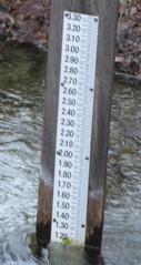
In 2009 HPWA began a study of water flow in this system of ponds and streams, in conjunction with the RIFLS (River Instream Flow Stewards) program of the Massachusetts Dept. of Fish & Game. The goal was a deeper understanding of the water budget of GHP: quantity of water delivered by LHP/Carters River to GHP; quantites supplied by rain/runoff, lost to evaporation, and provided by springs and sinks in GHP. How quickly would pollution be flushed away, i.e. what was the residence time of water in GHP? RIFLS staff (Cindi delPapa and Laila Parker) installed and maintained three staff gauges: at the flume just downstream of LHP; at Carter’s Bridge just upstream of GHP; and just upstream of Sandy Pond Bridge in Herring River, about 100 feet south of the concrete barrier defining the southeastern edge of GHP.
RIFLS staff calibrated the gauges and did frequent water flow re-calibrations. Volunteers from HPWA (mainly present President Brian Harrington and Water Quality Committee Chair at the time Eb von Goeler) monitored water levels at the three locations by reading the gauges about once or twice a week, and logging the data at the RIFLS site. Daily rainfall and temperature measurements were taken at a location close to the middle of GHP (28 Eagle Hill Dr.), with the results periodically transmitted to the RIFLS site. So far data from the years 2012 and 2013 have been analyzed and can be found by clicking here.
Summary Facts
Great Herring Pond Little Herring Pond
Elevation: 34 ft. 36 ft.
Total volume: 2.9 x 10⁹ gallons 0.98 x 10⁶ gallons
Total surface area: 376 acres 90 acres
Average depth: 22 ft. 3 ft.
Maximum depth: 45 ft. 4 ft.
Total Watershed Surface Area: 4440 acres = overlying the Sole Source Plymouth Carver aquifer